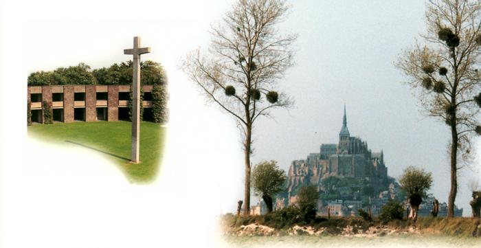
NORMANDY BATTLEFIELD TOURS – BATTLE SITE MAP
Most of the black and white pictures that will appear when you click on a battle site below were photographed by Major J.C. Hatlem in the late 40s. They were referenced by General Dwight D. Eisenhower and Carlton Joyce when they authored their books: “Crusade in Europe” and “Stand Where They Fought” respectively. Notations on some of the photos were made by General Eisenhower. For additional photo/battle details, read the chapter in “Stand Where They Fought.”

1
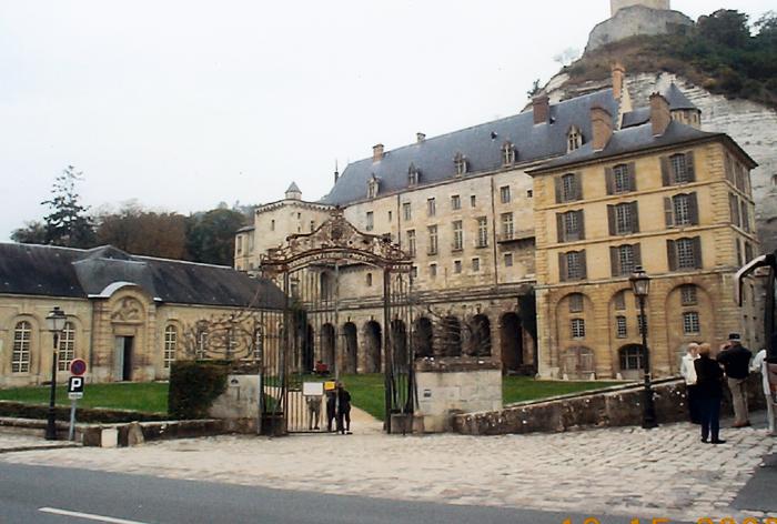
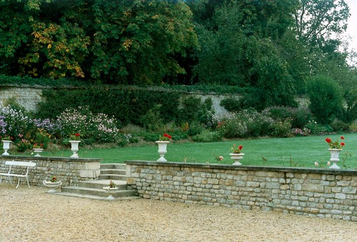
La Roche Guyon – Looking East Today
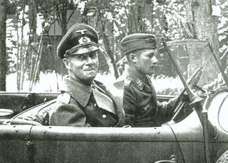
Forty miles north of Paris on the Seine River’s eastern bank. La Roche’s 67 citizens were occupied by 937 Germans as this was Field Marshal Erwin Rommel’s Army Group B Headquarters. His office was behind the three windows above the lamp post to the right. The chateau entrance is to the right of the photo. The lower buildings to the left are the horse stalls and carriage house. Rommel rushed back on June 6 from his wife’s birthday party arriving late that evening. He was returning from the battlefield south of Caen July 17 when his Horsch car was strafed and he was wounded.
2
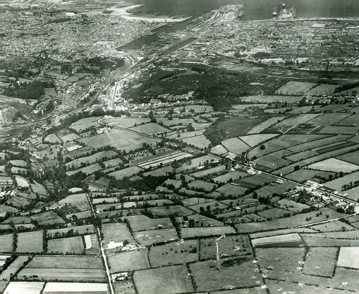
Cherbourg – Looking North
August 13, 1947
Napoleon designed the port and its defenses to be the Gibraltar of the English Channel. It was captured by Major General Erwin Rommel June 19. 1940. In anticipation of the 1944 invasion and to deny the port’s use by the Allies, Rommel had the defenses expanded around the circumference. Fort Roule, mid-photo, is a dominating honeycombed mountain with little accessibility. Although the city and port were captured June 26 (D-day + 19) German demolition of the port facilities denied its use for several months thereafter.
3
Maupertus Airfield- Looking North
August 3, 1947
The airfield, five miles east of Cherbourg, was an integral part of Cherbourg’s land-side defenses. Cherbourg’s outer port breakwater can be seen in the top left. The airport, Strongpoints Osteck and Seadler and the Hamburg Battery are in the center. The three battalions of the 22nd Regiment started their attack from the south and east D-day + 19. It fell the following day. The airfield, designated ALG (Advanced Landing Ground) A-15 became operational D-day +21 although beside the runway stood a pile of bombs, shells, duds and 600 mines lifted from the airfield. Prime Minister Churchill landed here July 20 as did General Charles de Gaulle August 20.

4
Quineville sur Mer – Looking West
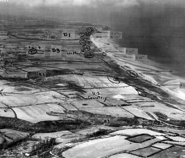
July 6, 1948
Strong beach defenses (strongpoint on beach shoreline mid-photo and along top of seawall). The chateau, bottom left, the 88mm casemate, mid-photo, near the ascending road and the church further up the hill witnessed strong German resistance on D-day +6 when attacked by the 3rd Battalion of the 22nd Regiment. The attackers came across the fields from the top left in the photo, descending upon the church and chateau 300 yards south. After subduing the Germans, K Company descended the road, battled the cement casemate gun crew but were stopped at the farm at the sharp corner. The capture of the seaside town was hard fought.

5
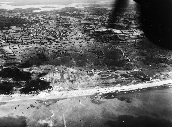
Utah Beach Looking West D-Day Morning
June 6, 1944
The aircraft engine nacelle and propeller are top right. Dark patches are cloud shadows. German flooding of the low pasturelands immediately west of the beach was planned to limit American accessibility to the higher ground. Further west along the top of the photo can be seen the flooded Merderet River valley, also a defensive tactic that caused grievous losses to the 82nd and 101st Airborne Divisions. On the beach, landing craft are bringing in General Barton’s 4th Infantry Division. Two causeways carry vehicles and men westbound to relieve the paratroopers holding the causeways western exits. Over the following months ships off loaded supplies and men across the beach in volumes comparable to the port of Philadelphia.
6
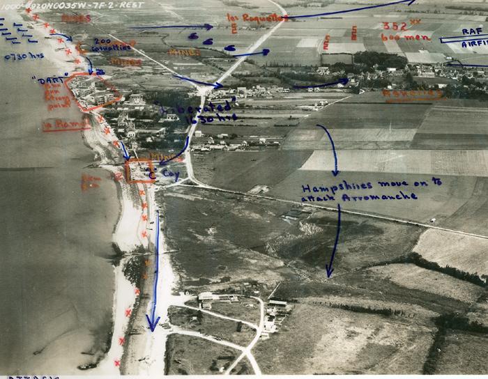
Ste Mere Eglise – Looking Southeast Today
American paratroopers of the 82nd Airborne Division erroneously parachuted into the town square in the early hours of D-day. M. Hairon’s burning barn, top mid-photo, illuminated the scene making it easy for the Germans in the square to shoot the descending troopers. Private John Steele’s parachute caught on the steeple. He survived by feigning death until the town was occupied in the daylight hours. His parachute effigy still hangs on the steeple. The airborne museum stands on the site of Hairon’s barn. The town has been a gathering point for returning veterans of all divisions.
7
la Fiere Causeway – Looking West
August 13, 1947
The low land over which the causeway passes was flooded in 1944. Many American paratroopers drowned here. Others were shot by snipers as they waded across the marsh. The road was important as the Utah invasion forces pushed west across the Cotentin Peninsula Peninsula. Captured intact without losses on D-day it was left unguarded to be occupied later that day by Germans recognizing its strategic value. The defenses occupying the farm buildings to the east end, foxholes along the causeway, and the western bank took a very heavy toll on the 82nd Airborne over a three day period. General “Jumping Jim” Gavin’s wartime foxhole is preserved along the road in the foreground. The “Iron Mike” airborne memorial is in the field across from the Leroux Manoir [foreground] overlooking the Merderd River valley.
8
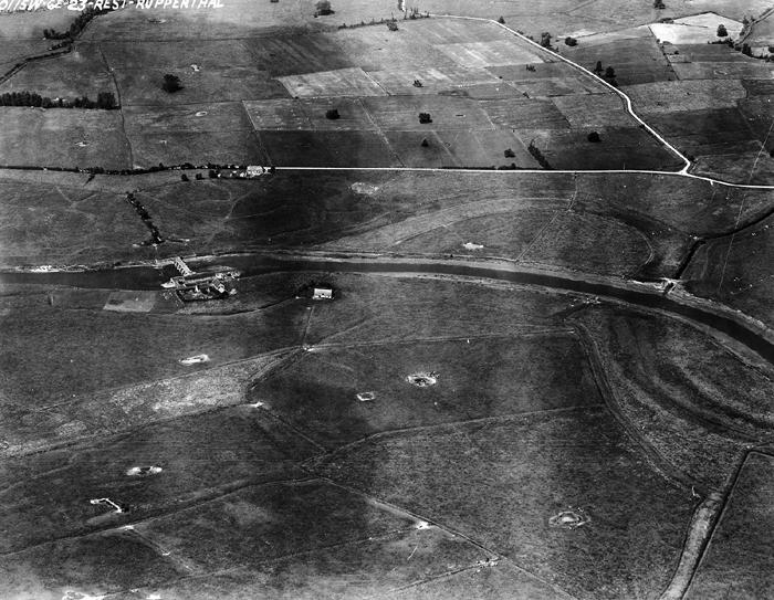
Chef du Pont Causeway – Looking North
August 13, 1947
This is one of two most southerly causeways crossing the flooded marshlands of the Merderet River. The other, la Fiere Causeway, is two miles north towards the top right in the photo. The elevated roads crossing the marsh were flanked by German manned foxholes. Attempts by the 75 paratroopers of the 505th Regiment were stopped at the bridge as the men left the town of Chef du Pont. American snipers took up positions around the smoke stacked factory picking off Germans lining the road. Other paratroopers who had landed in the fields west of the marsh (top of photo) attacked the Couffey farm (center left) successfully. The causeway was cleared by D-day +3 allowing the Utah landed troops and tanks to move west to cut off the Cotentin Peninsula.

9
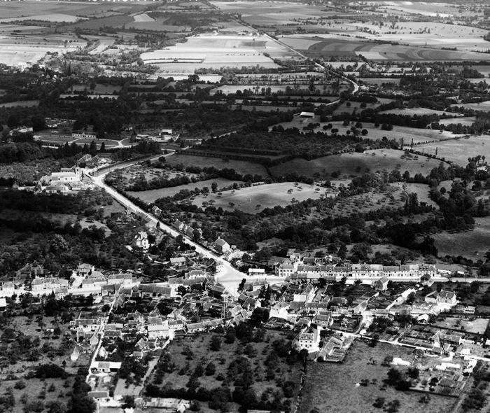
Vierville Road – Looking East
June 14, 1948
The road connects a major north-south highway to Utah Beach four miles east. Germans held the hedgerows and farm buildings adjacent to this tactically valuable roadway. This winding, narrow two miles is one of the most bloodied roads in the annals of the 101st Airborne Division’s Normandy history. Paratroopers of Colonel Robert Sink’s 506th Regiment landed outside the top of the photo. The subsequent battles to seize the road and open it up to traffic from Utah fills many pages. The converging roads at the bottom meet at the Liberte’ Expressway. A 2001 TV mini series, “Band of Brothers” will depict the Vierville Road battle in an early episode.
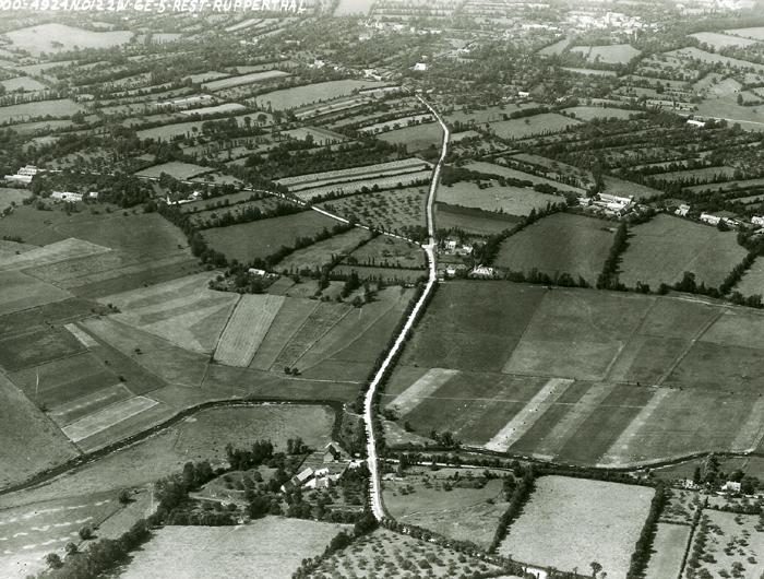
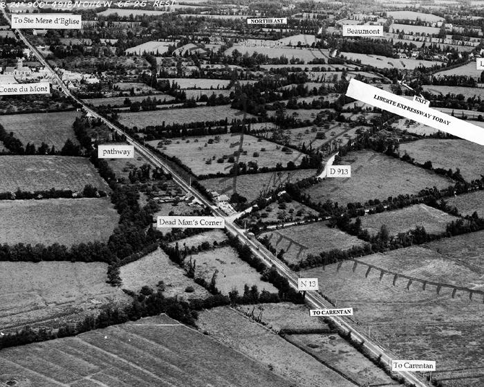
10
Deadman’s Corner – Looking North
June 14, 1948
The road entering from the right is from Utah Beach, 4 miles northeast. On D-day, resistance along the road and adjacent fields were costly to Colonel Robert Sinks’s 506th Regiment of the 101st Airborne Division. German Colonel van der Heydte, commander of the 6th Parachute Regiment was headquartered in Ste Come du Mont half a mile north of the intersection. Fighting around the important corner lasted several days until the Germans were forced to withdraw westward, their only line of retreat. From here the Americans pushed south to Carentan and north to Ste Mere d’Englise opening up the advance from the Utah beachhead.
11
Carentan Causeway- Looking North
August 13, 1947
To link the Omaha and Utah forces the capture of Carentan was essential. It’s northern side buildings are seen to the bottom. The low land was under three feet of water in June 1944. Colonel Robert Cole’s 3rd Battalion of the 502nd Regiment moved south from Deadman’s Corner, seen at the top right, on D-day+ 4. The German 6th Parachute Regiment had withdrawn along the elevated railroad line, seen on the left side, and deployed at the farm and along the road connecting the highway and the railroad. Snipers hidden in the marshes flanking the highway picked off Cole’s men moving south. By dawn the following day Cole and 265 men were at the south end of the causeway. They launched a bayonet attack westward along the connecting road axis clearing out the farm and orchards and then moved to the railroad overpass. The few remaining German paratroopers withdrew into Carentan.
12
la Barquette Lock- Looking North
August 13, 1947
German control of back flooding the lowlands behind Utah Beach and the Douve and Merderet River valleys was accomplished by opening and closing the lock gates at the appropriate times over a two year period. Colonel “Skeets” Johnson, commander of the 501st Regiment of the 101st Airborne Division, attacked from the north early D-day morning with 150 men. The Germans withdrew south several hundred feet to prepared positions. US Navy counter fire against two German 88s in Carentan silenced the Germans. On D-day +1 German paratroopers of the 1st Battalion, 6th Parachute Regiment attacked from the top right towards the T-junction. Although out-manned the Americans bluffed the Germans into surrendering. In error German artillery killed many of their comrades as the POWs were being marched into captivity. Today, the Liberte’ Expressway across these lowlands near Carentan passes very close to the lock.
13
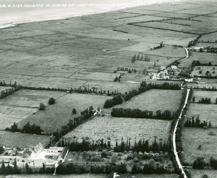
Gefosse Fontenay – Looking North – June 14, 1948
A hamlet southwest of Grandcamp-les-Bains
On D-day +2 German troops boarded a bullet riddled American landing craft that drifted onto this beach. Aboard were six dead naval officers, one slumped across his water soaked briefcase containing the invasion plans and the follow-up ninety-day timetable. Copies were sent to German headquarters however, skepticism treated the information cautiously. Although this information confirmed there were no other invasion planned in the Calais area no German divisions were shifted into this area to strengthen the German positions.
14
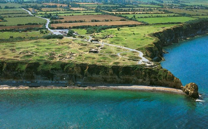
Pointe du Hoc – Looking South Today
The guns housed in cement casements were a major threat to the invasion forces off Omaha and Utah Beaches. Bombing had not destroyed the positions. Companies D, E and F of Colonel James Rudder’s 2nd Ranger Battalion landed at the base of the cliffs at 7:00 AM. Hand grenades and machine gun bullets thwarted the Rangers climbing ropes to the top. Of the 225 in the assault only 120 made it to the plateau. The casements were empty with only camouflaged telephone poles as decoys. The Rangers moved south to the coast road intersection discovering a six howitzer field battery. Sergeants Leonard Lomell and Jack Kuhn using thermite grenades demolished the firing and sighting mechanisms. German counterattacks compressed the Rangers back to within 50 feet of the cliff face which they held until relieved by Omaha landed forces on D-day +2.
15
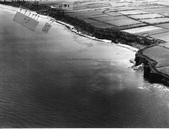
Omaha Beach- Vierville Looking East
June 14, 1948
The valley road “the Vierville Draw” or code named D1 is at the top. Six German strongpoints defended the beach in this area. The movies “The Longest Day” and “Saving Private Ryan” depict the battle on these sands. C Company of the 2nd Ranger Battalion landed under the cliff immediately west of the draw. Their battle along the bluff greatly reduced the firepower on A Company, 116th Regiment assaulting the beach. Further west to the right is Pointe Percee from where a German officer observing the battle erroneously misjudged the American successes and redirected German reinforcements to another area. The German defenses around Vierville draw are visible and accessible.
16
Omaha Beach and Bluffs – Looking West
February 22, 1949
The plateau is 150 feet above sea level. It is several hundred yards from the high tide line to the foot of the sloping bluffs. The beach obstructions were removed shortly after D-day. Five valleys (identified as D1, D3, E1, E3 and F1 not shown) run through the plateau down to the beach. German concrete pillboxes still abound along the bluffs and along the valley walls. The heaviest fighting with the highest casualties occurred when our troops landed at the mouth of these fortified valleys. The development of the US Normandy Cemetery can be seen in the center.
17
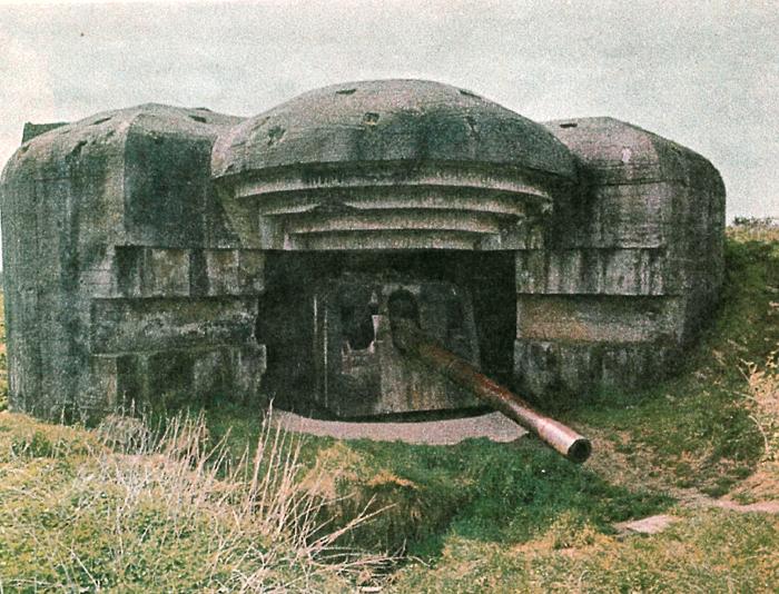
Longues Battery – Looking South Today
Four 155mm guns in thick concrete casements were positioned along the bluffs between Arromanches and Omaha Beach. A hard fought duel was fought between the guns and the battleship HMS Warspite. One of the 16-inch naval shells entered the gun embrasure exploding among the ammunition. The explosion vaporized the German crew blowing the casement apart like giant toy blocks. British troops captured the position late D-day. The site had changed little and is readily accessible by automobile including the observation and fire control bunker built into the cliff face.
18
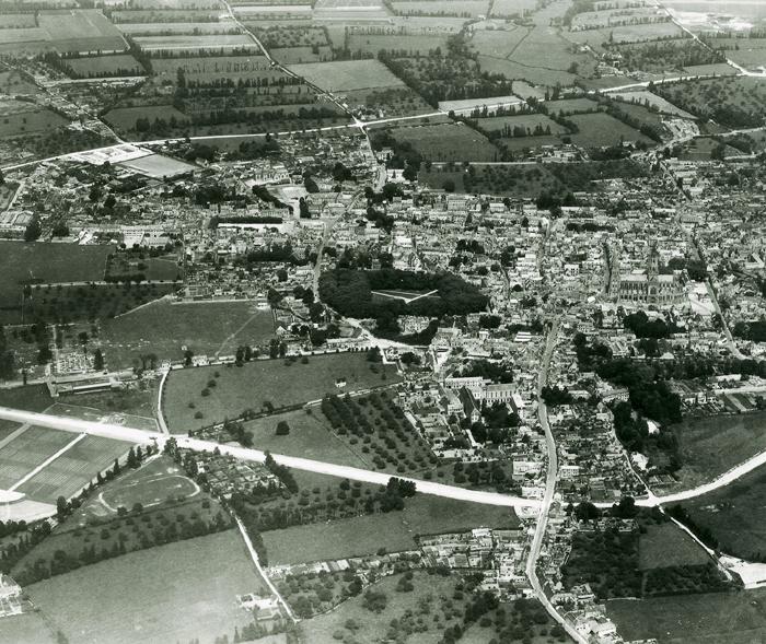
Bayeux – Looking North
July 2, 1948
The city was not bombed, shelled or fought in. The magnificent cathedral and site of the Bayeux Tapestry Museum were spared war’s destructive force. It was liberated by the British on D-day +1. Bayeux’s narrow, ancient streets prohibited the rapid flow of military traffic so the British engineers built bypass roads to the north and south. In the photo (lower left) is the British wartime cemetery containing 4018 British, 181 Canadian, 25 Polish and 466 German gravesites. All casualties of the battles to the south. The British do not permit exhumations and transfers of remains to other national cemeteries.
19
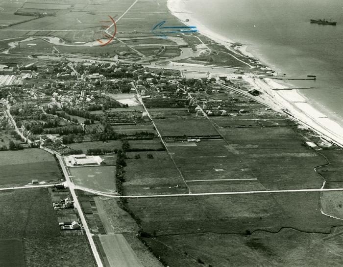
Port en Bessin- Looking North
June 14, 1948
Captured by the 47th Royal Marine Commandos the morning of D-day +1 entering from the south along the main road. By D-day +6 the port was reopened with off loading of about 8,000 tons per day. In early July floating pipelines connected fuel and oil tankers to the large petrol dump immediately west of the town. The German pill boxes on the west and east headlands overlooking the harbor and its approaches are still present. The commandos cleared the town quickly and continued westward to link up with the American forces moving eastward from Omaha Beach. The four storied building on the east side of the port entrance was demolished in the making of the movie “The Longest Day”, 1963.

20
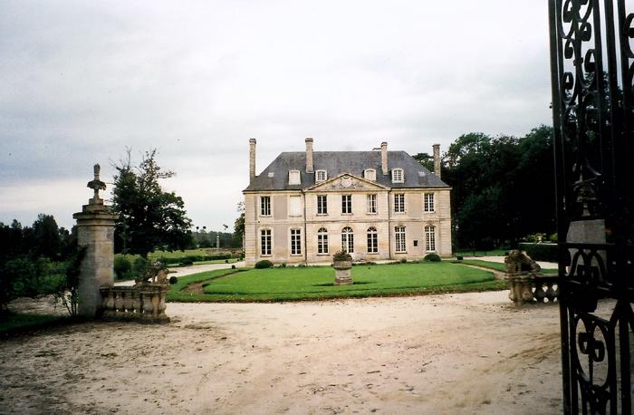
Creully – Looking South Today
Field Marshal Bernard Law Montgomery’s headquarters for two weeks in June 1944. His sleeping caravan was kept under the trees to the right. The front lines were two miles to the left. Winston Churchill spent a day here. A week later King George visited but upon his return to London the British press described the chateau’s location so completely that the Germans started shelling the area forcing Montgomery to abandon the site and move to Blay near Bayeux.
21
Chateau Adrieu – Today
The chateau was occupied by a regiment of the 12th SS Panzer Division D-day +1. The area saw much fighting with British and Canadian troops. POWs were brought here and twenty were shot by their guards along this wall. The officer responsible was later killed along with the perpetrators of the murders. The chateau has been rebuilt and is now a five star hotel with shrapnel in the ceiling of the higher rooms as evidence of the battle.
22
Le Hamel – Looking East
June 14, 1948
The British Hampshire Battalion of the 50th Infantry Division assaulted Gold-Jig-Red-West Beach at 7:30 AM D-day at the sandy beach top left. Beach obstacles, minefields and enemy resistance took 200 casualties in the first hours. Only five of their sixteen tanks made it beyond the minefields. Moving west accompanied by one tank the Hampshires attacked a 75mm strongpoint codenamed “Dart”. C Company bypassed Dart to attack a 50mm strongpoint on the town’s west side. German resistance was completely overcome by 4:30 that afternoon. The battalion continued to Arromanches where the following day British engineers commenced building Port Churchill assembled with components floated across the English Channel.
23
Asnelles sure Mer – Looking North
June 14, 1948
This is the British 30th Corp Gold-Jig Beach D-day assault area. Asnelles is the village in the center of the photo. Close support by the air force and navy subdued the beach defenses quickly causing relatively light casualties to the attacking British 50th Division. The 231 Brigade moving west however met stiffened resistance as they moved along the coast road towards le Hamel and Arromanches. The 56th and 151st Brigades supported by the 7th Armored Division moved rapidly south reaching the Bayeux outskirts D-day evening.
24
Courseulles sur Mer – Looking West
June 14, 1948
The western end of the Canadian 3rd Infantry Division D-day assault beach east of the breakwater was codenamed “Nan-Green beach”, attacked by the Regina Rifles Regiment. Note the concrete blockhouse on the shoulder of the coast road is still present as are several more in the dunes west of the breakwater. West of the river mouth Mike Green and Mike Red Beaches were assaulted by the Royal Winnipeg Rifles. Coordination of tans and infantry landing together overcame the German resistance quickly without heavy losses to the two Canadian regiments.
25
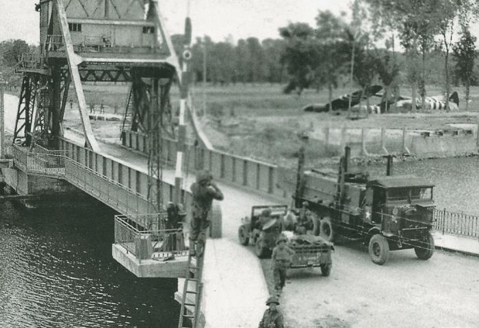
Pegasus Bridge – Looking East
June 12, 1944
The lift bridge spanning the Orne Canal was captured by British 6th Airborne Division glider troops in the first few minutes of D-day. The three Horsa gliders, visible in the top right brought Major John Howard and his troopers in on time, accurately placing them in position to seize the bridge by rapid surprise. Lt. Den Brotheridge, the first allied death on D-day was killed where the Jeep is standing as he and his men rushed across the bridge from the eastern side. A Bedford 4×4 engineer’s truck is returning from the airborne headquarters area to secure supplies from Sword Beach. The drivers, although in Europe, are still driving on the left side as in England.
26
Abbey Ardennes – Today
The old Abbey of the 13th century was a farming commune in 1944. The German 12th SS Panzer Division occupied it D-day afternoon. Its tall turreted chapel afforded excellent observation of the southerly advancing Canadians. The following afternoon the SS men attacked the exposed Canadian flank at Authie. Canadian POWs were shot on site. Eighteen were brought singly into this garden, shot in the back of the head and buried in shallow graves. Colonel Kurt Meyer, the officer in charge, was held accountable, tried and condemned to be shot. The authorities diminished his sentence. He was released and after a beer salesman career selling to the allied army clubs, died of a heart attack at age 63.

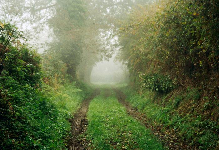
27
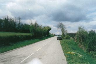
Hedgerow Country Today
The battles for St. Lo were fought in the bocage area of Normandy. In the area of a football field there are 100 small farmed fields surrounded by impenetrable 1000-year-old hedges growing on thick foundations of stone, rock, earth and roots. Tree limbs meet covering the dirt farm track. German covered foxholes were established during the occupation. Burrowing through the hedgerow foundations the defenders could fire down the road and scurry back through their tunnel to the safety of their foxhole in the field. Mortar air burst shells impacting in the overhanging branches scattered deadly shrapnel onto the advancing Americans.
28
Marigny – Looking North
July 3, 1948
On July 25 (D-day + 49) General Omar Bradley launched Operation Cobra with 15 divisions and 750 tanks from their positions a few miles north of Marigny (top center). The 2nd SS Panzer Division rushed north to the town. The American forces counterattacked from the fields to the right and left of the road being used by the panzers. The enemies’ resistance was strong. Two days later the American 3rd Armored Division reached the intersection sending half its strength west to Coustances while the remainder continued south at full speed. This north-south road was the principle thrust line for the famous Patton Breakout.

29
Mortain – Looking North
July 3, 1948
Patton’s Breakout and Breakthrough brought the American 30th Division and a few tank squadrons of the 3rd Armored Division into Mortain August 3 (D-day + 58). The Germans launched a major counterattack westward five days later by passing Mortain to the north and south. Roadblocks at the towns’ entrances slowed the attack. On the rocky prominence (top right) called Hill 317 the 2nd Battalion of he 120th Regiment held out for five days. Ammo, food and medical supplies were shot onto the hill unsuccessfully. French citizens using little known paths kept the Americans supplied. This is one of the most historically outstanding unit achievements in the Western Europe Campaign.
30
Pontaubault – Looking North
July 3, 1948
Patton’s Third Army rushed across these two bridges July 31. The Selune River bridges had not been destroyed. Pivoting west, Patton led his forces into Brittany and its large port at Brest. Those forces pivoting east rushed to Paris and the Seine River bridges. Patton defended these two lifelines coming from the north with hundreds of antiaircraft guns and an ever-present air umbrella over the corridor. German Colonel Rudolf Bacherer with a thousand men of the 77th Division attempted a brief but unsuccessful counterattack in the hours before the main American force entered the scene.
31
Mont St. Michel
The thousand year old church and village are located on an island half a mile off the coast connected by an elevated causeway. On the mainland a short distance away is the German Mont de Huisenes Cemetery, an ossuary of 11,956 remains from the battle casualties in Brittany.
32
St. Lambert sur Dives – Looking East
July 1948
On August 19, a German Tiger tank occupied the town intersection facing north holding open one of three escape routes for the defeated and surrounded German army in Normandy. As the Germans fled eastward along the road and neighboring fields and orchards the Allied air force incessantly bombed and strafed. Canadian artillery added to the inferno. With the road from the north as its axis of advance B Company of the Argyll and Sutherland Highlanders (Canadian infantry) and C Squadron of the South Albert regiment (armored) took six hours to fight their way to the intersection and knocked out the Tiger tank. Canadian Commander Major David Currie (awarded the Victoria Cross) renewed the artillery fire to further help close the escape route successfully. The town was pulverized, the roadways were littered with hundreds of abandoned and destroyed vehicles and equipment. Hundreds of horses and thousands of German soldiers lay dead within the limits of this photograph.
33
Chambois – Looking Northwest
July 6, 1948
The road running from bottom left to top right was one of three German escape roads from the “Cauldron” in mid-August. American units of the 90th Infantry Division moved towards the town intersection from the bottom of the photo. Elements of the Polish 10th Armored Rifle Regiment moved towards the intersection from the top of the photo. American Captain L. E. Waters and Polish Major Zgorzelski met and shook hands at the intersection at 7:20 PM August 19. Although closing this route the retreating Germans continued to flee eastwards across the fields and orchards. The allied linkup was tenuous.

34
The Escape Corridor – Looking East Today
This August 4, 1944 photo (top right) shows this road, one of three used for German retreat from the Falaise Pocket, littered with destroyed tanks, vehicles, wagons, slaughtered horses and slain soldiers. Two Polish Sherman tanks are seen standing on the grassy slope to the left, their guns aimed towards the road. The Polish Armored Division moving from the north fought up to this hilltop overlooking the German eastbound retreat route between Chambois and Vimoutiers. The Polish firepower combined with artillery support and fighter bombers decimated the trapped Germans. Attacks to dislodge the Poles from their positions were costly to both sides.
35
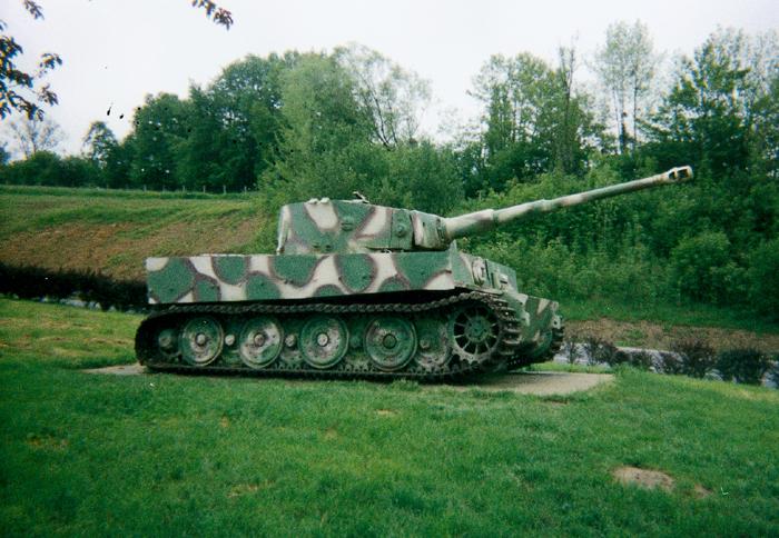
The Vimoutiers Tiger Today
This Tiger tank monument facing west is on the eastern exit road at Vimoutiers. Panzers were used to keep open the German escape corridor from the Falaise Pocket (the “cauldron”) in late August. The tank facing west is symbolic of its action. There are many Tigers in museums but only one or two are outdoor monuments in France.
36
Rommel Strafed – Looking North Today
Field Marshal Erwin Rommel, returning from the Bourguebus Ridge battlefield on July 17 at 6:30 PM, was strafed by a British Spitfire here. Racing quickly, Rommel’s driver came over the hill attempting to turn into the factory driveway by the gatehouse. Under machine gun fire the car careened into the ditch in the right-hand foreground. Rommel lay in the middle of the road at the 6th white line with head injuries. He was rushed to the Bernay hospital.
Hosting and Development
Powered by
Developed by